 |
| Sheep graze contentedly on the other side of the Mataura River, a popular fishing spot |
In the morning, I get lost in traffic and miss the turnoff
to the coast. I don’t even make it into the
city, but from what I can see, Invercargill looks just
like the inner suburbs of Melbourne - Malvern perhaps, flat and comfortable,
with older Federation style homes set in generous gardens.
I eventually come out near the estuarine coast of the Mataura
River, where there are 400 hectares of tidal flats teeming with fish. Toetoes Bay, where the river meets the sea, was already a popular fishing spot and a place of permanent settlement for the Maori, long before the arrival of Europeans. It was also an
important trading centre for surrounding tribes where poumani (greenstone) from the west, stone from Central Otago and
obsidian from the north were traded. Today, the region is regarded as New Zealand’s biggest
brown trout fishery (a more successful introduction). Whitebait, salmon and flounder are also abundant here and modern day fisherman
have built their shacks and cribs around it.
 |
| A typical 'crib' along the Mataura River |
 |
| Another - The Highway Hilton |
 |
| More |
The whale rush began after one Tommy Chasland caught 11
whales in 17 days in Toetoes Bay in 1835. The news brought hundreds of whalers from all
over the world - from the UK, from France and particularly from the USA,
making Fortrose* an important shipping and supply base. Whalers also set up one of their
shore -based stations here and later ended up supplying and trading with passing
ships. Some of the Doubtful Sound whalers settled here and married into Maori families. Fortrose prospered until 1899 when the railways came and ended the reliance on sea transport.
 |
| A trypot on the beach at Fortrose recalls the days of whaling |
The lonely
lighthouse near the eastern
end of the
bay, owes its existence to a tragedy – the 1881 sinking of the
Tararua, New Zealand’s worst civilian shipwreck,
with the loss of 151 lives. Sixty -four of the victims are buried in a farmer's
field nearby - the Tararua Acre, because it was too difficult to transport them
to the nearest town.
 |
| This
lonely wooden lighthouse keeping watch over windswept Waipapa Point
(1884) attests not only to the precariousness of life at sea, but
also the difficulty of a lighthouse keeper's life. You could say that
lighthouse keepers were among the earliest casualties of automation. When
this one was connected to electricity in 1943, one keeper lost his job.
The remaining one did so in 1976 when New Zealand's lighthouses were
automated |
Inland there are some lovely
waterfalls. I visit
McLean Falls, then miss a major one, The Matai Falls, while trying to see the
Purakaunui Falls. I get there via a torturous back road, after following a sign
on the highway.
The falls are lovely,
but since I haven’t seen any cars on the road, I am surprised to see so many people
there already.
Then I discover that
there’s another, much shorter sealed road leading back to the highway (closer to Dunedin) on the other side of the carpark.
 |
| McLean Falls (22m), has three tiers and is in a lovely rainforest setting |
 |
| There are native fuchsias here which grow 12 metres tall |
 |
| Second Waterfall of the day - Purakaunui Falls, (22 mts.) |
 |
| Barr's Falls, my third waterfall of the day, not counting Niagara Falls (see below) |
I come upon
Barr's Falls, a lovely double waterfall, by accident. It's just another little sign on the road, like the one for Purakaunui Falls, and much smaller than the one for
Niagara Falls.
 |
| I won't show you this one but I'll give you a hint - it was named by an American surveyor who was either very homesick, slightly demented or had a wicked sense of humour |
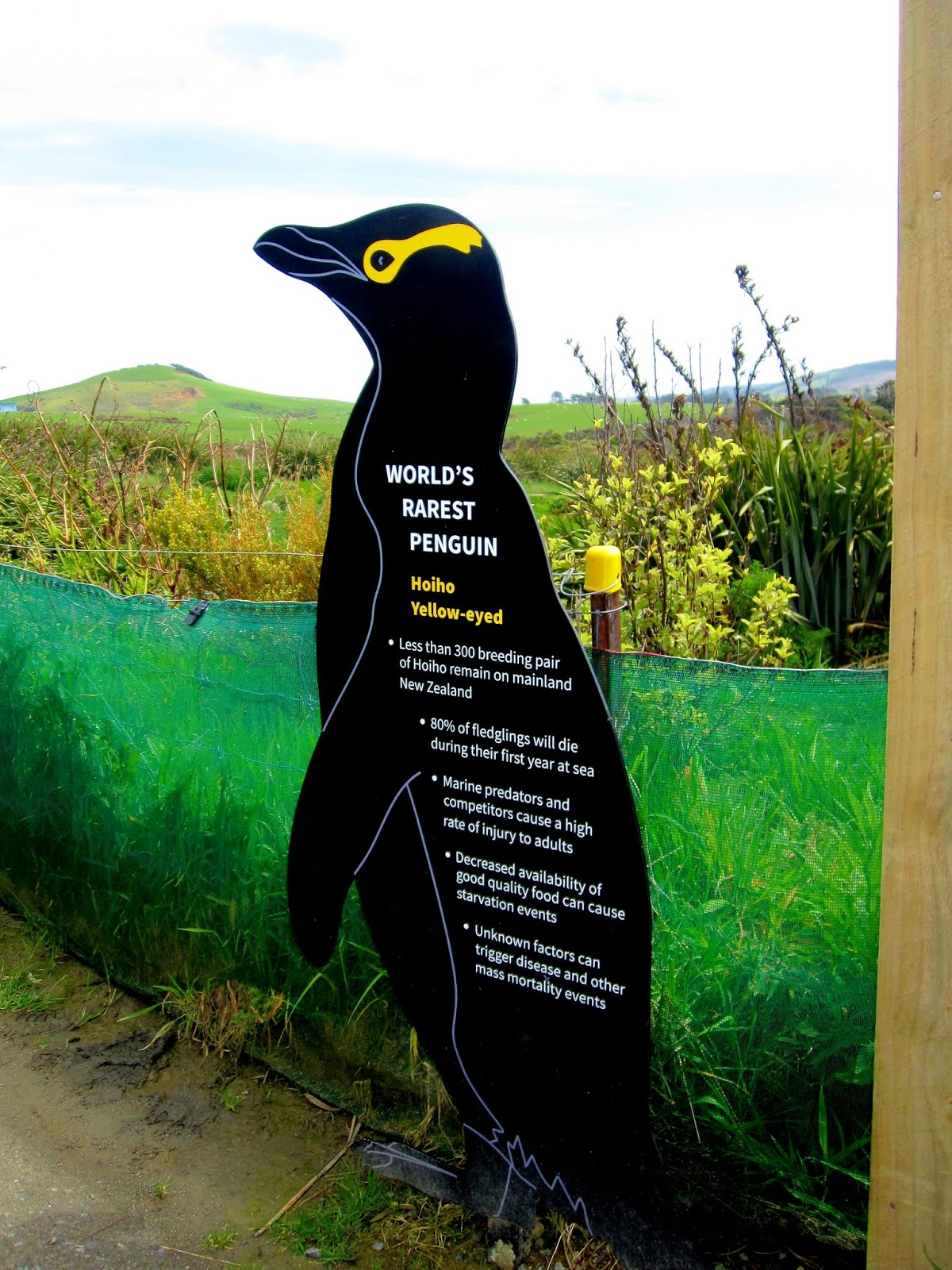
Further along, at Curio Bay there’s a fossilised forest and it
is also the home of yellow – eyed penguins, the rarest in the world. The
facilities are good, there’s a café,
good signage and plenty of conservation work going on, but while the
forest maybe of immense paeleontological significance, there isn’t much to see today and no penguins either.
 |
| This is the 170 Million year old fossil forest at Curio Bay |
 |
| Alas, I don't get to see a live Hoiho, the world's rarest penguin, though they are said to live around Curio Bay. There are only 300 pairs left in New Zealand |
Still a bit early for my stay at Surat Bay, I make a detour to
Jack’s Point.
Tuhawaiki, known to the sealers and whalers as “Bloody Jack,” was a paramount
chief in this region and a signatory to the
Treaty of Waitangi, New Zealand’s
Founding Document (
June 9, 1840). He
was also among the first to begin trading with the whalers and soon owned his
own sailing ship and traded as far away as Sydney.
Not that the Maori didn't have their own sea -going craft - they had both single and double hulled canoes, well before the arrival of Europeans. A number of other places are
also named after Jack besides this one.
 |
| Jack's Blowhole is close by. It gives you an idea of the ruggedness of the coastline |
Jack’s Point is a
busy place. It has a lovely sandy beach and there are holiday cottages all along its foreshore. People are
walking dogs and about half a dozen children are doing trailbike stunts. As I walk
along the beach, I see a a solid black shape on the beach about 500 metres
away
- my
first sea lion. I hurry over
the wet sand with my camera, jumping puddles and dodging trailbikers.
Just as I’m getting close two frisky dogs – a
terrier and a larger one, start yapping at the sea lion and then the
trailbikers come. That’s enough for the sea lion – it launches itself back into
the waves before I get there.
Nevertheless
I’m quite thrilled to have seen one
even
this close. They are larger than the fur seals - males can reach
350 -500 kg, with females around half that, and prefer beaches to basking on rocks. They almost became extinct too,
surviving only on a few offshore islands. Although the current population is estimated to be around 12,000, they aren’t out of danger yet.
Counts in the 1990's showed there to be around 15,000 with the setback believed to be due to an intervening disease outbreak.
 |
| What a shame the locals (or visitors for that matter) can't read! |
 |
Sunset at Surat Bay
* In the signage along the beach at Fortrose, I noticed that there was a reference to the Mariori. This won't mean much to most people, but in Geography we learned that the peace -loving, pottery making Mariori, had been completely oblitered by the more warlike Maori. To be sure, they probably just kept the women (as Chingiss Kahn did with the Allens and other vanquished tribes) but at least some part of their bloodline survives, as did that of the Allens. I do hope my Geog 1. Lecturer reads this!
|


Comments